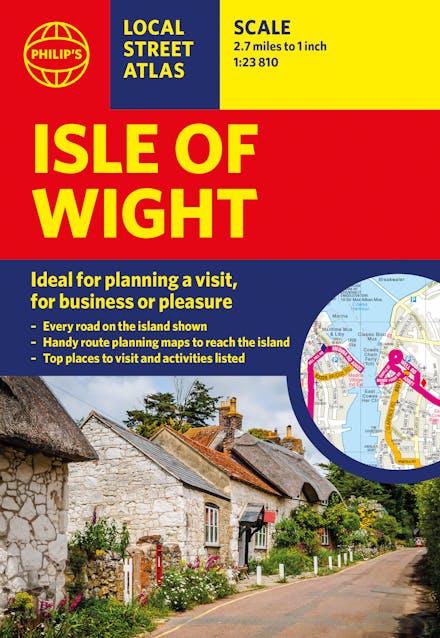
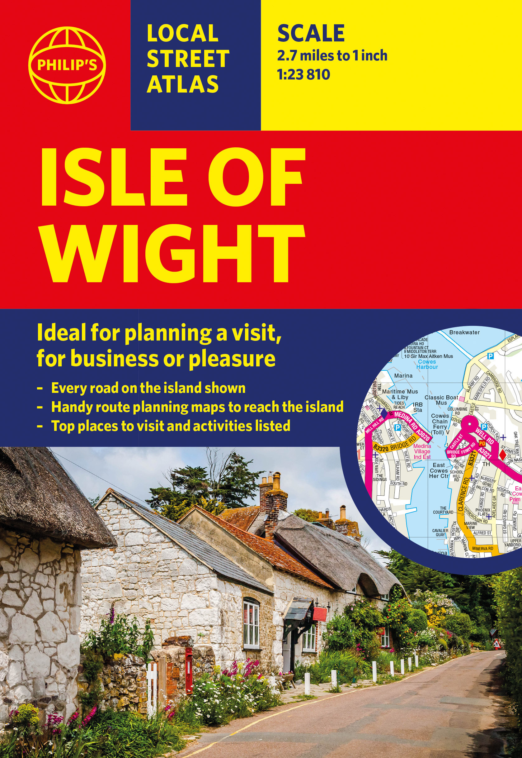
Philip's Isle of Wight: Local Street Atlas

Philip's Maps

Formats & Editions

This pocket-sized street atlas of the Isle of Wight gives detailed coverage of the whole of the island.

This local street atlas of the Isle of Wight gives detailed coverage of the whole of the island at a scale of 2 2/3 inches to 1 mile. Important for ferry links to the Isle of Wight, the mainland towns of Southampton, Gosport, Lymington and Portsmouth are included at the same scale. Central Portsmouth is also shown at the enlarged scale of 5 1/3 inches to 1 mile.

Full of useful tourist information and all the sights and activities available on the Isle of Wight, the maps also show hospitals, car parks, post offices, leisure facilities, schools, industrial areas and retail areas, while the index lists street names and postcodes.

Extra contents include an 8-page route-planner, marking all major and minor roads on the island together with an area on the mainland taking in the New Forest to the west and Emsworth to the east, plus a 4-page guide to the top visitor attractions.

Pocket sized, the atlas is ideally suited for both business and leisure use, whether by locals or visitors.

Read More

More books by Philip's Maps

Philip s Road Atlas Britain & Ireland
Philip's Maps
Philip s Road Atlas Britain & Ireland
Philip's Big Road Atlas of Britain and Ireland
Philip's Maps
Philip's Big Road Atlas of Britain and Ireland
Philip's France and Spain Road Atlas
Philip's Maps
Philip's France and Spain Road Atlas
Philip's Big Road Atlas of Europe
Philip's Maps
Philip's Big Road Atlas of Europe
Philip's Easy to Read Multiscale Road Atlas of Europe
Philip's Maps
Philip's Easy to Read Multiscale Road Atlas of Europe
Philip's Big Easy to Read Britain Road Atlas
Philip's Maps
Philip's Big Easy to Read Britain Road Atlas
Philip's Easy to Read Road Atlas of Britain
Philip's Maps
Philip's Easy to Read Road Atlas of Britain
Philip's Atlas of the World
Instit Of British Geographers, Philip's Maps
Philip's Atlas of the World
Philip's Big Easy to Read Scotland Road Atlas (Spiral A3)
Philip's Maps
Philip's Big Easy to Read Scotland Road Atlas (Spiral A3)
Philip's Trucker's Big Easy to Read Trucker's Road Atlas of Britain
Philip's Maps
Philip's Trucker's Big Easy to Read Trucker's Road Atlas of Britain
Philip's RGS World Atlas (A4)
Philip's Maps
Philip's RGS World Atlas (A4)
Philip's RGS Complete (aka OUP Concise) World Atlas
Philip's Maps
Philip's RGS Complete (aka OUP Concise) World Atlas
Philip's Big Easy to Read France, Spain & Portugal Road Atlas
Philip's Maps
Philip's Big Easy to Read France, Spain & Portugal Road Atlas
Philip's Great British Road Trip Atlas
Philip's Maps
Philip's Great British Road Trip Atlas
Philip's Planisphere (Latitude 51.5 North)
Philip's Maps
Philip's Planisphere (Latitude 51.5 North)
Philip's Concise Atlas Britain
Philip's Maps
Philip's Concise Atlas Britain
Philip's Europe Road Map
Philip's Maps
Philip's Europe Road Map
Philip's Navigator Scotland
Philip's Maps
Philip's Navigator Scotland
Philip's Road Atlas France, Belgium and The Netherlands
Philip's Maps
Philip's Road Atlas France, Belgium and The Netherlands
Philip's Navigator Britain Easy-Use Format
Philip's Maps
Philip's Navigator Britain Easy-Use Format
Philip's Children's  School Atlas
David Wright, Jill Wright, Philip's Maps
Philip's Children's School Atlas
Philip's RGS Infant School Atlas
Philip's Maps, David Wright, Rachel Noonan
Philip's RGS Infant School Atlas
Philip's Essential School Atlas
Philip's Maps
Philip's Essential School Atlas
Philip's Junior School Atlas
Philip's Maps
Philip's Junior School Atlas
Philip's Modern School Atlas
Philip's Maps
Philip's Modern School Atlas
Philip's Navigator Wales
Philip's Maps
Philip's Navigator Wales
Philip's Street Atlas Devon
Philip's Maps
Philip's Street Atlas Devon
Philip's Street Atlas Norfolk
Philip's Maps
Philip's Street Atlas Norfolk
Philip's Street Atlas Wiltshire and Swindon
Philip's Maps
Philip's Street Atlas Wiltshire and Swindon
Philip's Street Atlas Derbyshire
Philip's Maps
Philip's Street Atlas Derbyshire
Philip's Street Atlas Nottinghamshire
Philip's Maps
Philip's Street Atlas Nottinghamshire
Philip's Spain and Portugal Road Map
Philip's Maps
Philip's Spain and Portugal Road Map
Philip's Street Atlas Buckinghamshire
Philip's Maps
Philip's Street Atlas Buckinghamshire
Philip's Street Atlas Oxfordshire Spiral
Philip's Maps
Philip's Street Atlas Oxfordshire Spiral
Philip's Street Atlas Suffolk
Philip's Maps
Philip's Street Atlas Suffolk
Philip's Certificate Atlas for the Caribbean
Philip's Maps
Philip's Certificate Atlas for the Caribbean
Philip's Compact Atlas Europe
Philip's Maps
Philip's Compact Atlas Europe
Philip's Navigator Camping and Caravanning Atlas of Britain
Philip's Maps
Philip's Navigator Camping and Caravanning Atlas of Britain
Philip's Navigator Trucker's Britain
Philip's Maps
Philip's Navigator Trucker's Britain
Philip's Isle of Wight Map
Philip's Maps
Philip's Isle of Wight Map
Philip's Navigator Britain
Philip's Maps
Philip's Navigator Britain
Philip's Street Atlas Bristol and Bath
Philip's Maps
Philip's Street Atlas Bristol and Bath
Philip's Street Atlas Lincolnshire
Philip's Maps
Philip's Street Atlas Lincolnshire
Philip's Street Atlas Somerset
Philip's Maps
Philip's Street Atlas Somerset
Philip's Street Atlas Cheshire
Philip's Maps
Philip's Street Atlas Cheshire
Philip's Street Atlas Cornwall and Plymouth
Philip's Maps
Philip's Street Atlas Cornwall and Plymouth
Philip's Compact Britain Road Atlas
Philip's Maps
Philip's Compact Britain Road Atlas
Philip's World Atlas
Philip's Maps
Philip's World Atlas
Philip's Ireland Road Map
Philip's Maps
Philip's Ireland Road Map
Philip's Italy Road Map
Philip's Maps
Philip's Italy Road Map
Philip's The Cotswolds
Philip's Maps
Philip's The Cotswolds
Philip's Highlands of Scotland
Philip's Maps
Philip's Highlands of Scotland

Related books